

Weather radar is a crucial technology in meteorology, playing a key role in tracking severe weather events and predicting atmospheric conditions.
This guide offers an in-depth look at how weather radar systems operate, exploring their functionality, different radar bands, advantages, limitations, and their essential contribution to weather forecasting.
Over time, weather radar technology has made remarkable progress, improving our ability to detect weather phenomena and provide accurate forecasts.
Yet, despite these advancements, there are still challenges to overcome, such as coverage limitations, range restrictions, and the complexities involved in detecting various types of precipitation, which can vary depending on the radar system in use.
Read More: Understanding Weather Radar: A Complete Guide to How Radar Works
Main Takeaways
Weather radar is an essential tool for monitoring and detecting a range of weather events, including rain, snow, hail, damaging winds, and tornadoes, and plays a crucial role in forecasting weather patterns.
Radar systems work by emitting electromagnetic waves and analyzing their reflections to assess precipitation characteristics. Different radar bands offer distinct advantages and limitations, influencing the accuracy and breadth of weather predictions.
Despite its value, weather radar networks can be costly to install and maintain, with some facing challenges such as limited coverage, blind spots, and difficulties in detecting certain weather phenomena.
Additionally, some temporary or ad-hoc systems struggle with financial sustainability and may go offline due to high operational costs. Accessing high-resolution radar data in real-time from a reliable and accurate source is essential for effective weather monitoring.
What Is a Weather Radar?
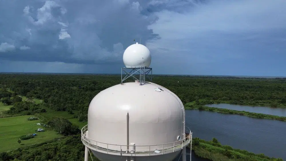
A weather radar is a key instrument in meteorology, commonly recognized by its distinctive large spherical shape mounted on a rotating dish or antenna tower. Its main function is to send out electromagnetic pulses into the atmosphere and measure the signals reflected back after interacting with precipitation particles.
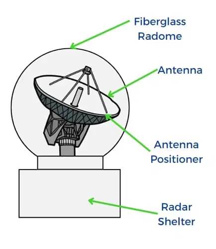
A weather radar system consists of several essential components: a transmitter that emits the pulses, a receiver that captures the reflected signals, and an advanced signal processor that analyzes the data.
This process allows meteorologists to assess critical information, including the location, intensity, type, and movement of precipitation within a specific area.
How Do Weather Radar Systems Work?
Weather radar systems operate based on the principle of Radio Detection and Ranging (RADAR), which involves emitting short pulses of electromagnetic waves into the atmosphere. When these waves encounter precipitation particles, they bounce back toward the radar unit.
By measuring the time it takes for the pulses to return and the strength of the reflected signals, the radar system can determine the distance to the precipitation, as well as its type (rain, snow, hail) and intensity.
However, radar technology has its limitations, particularly in detecting subtle weather conditions like light drizzle or in distinguishing between different types of precipitation. These challenges can vary depending on factors like radar frequency and the distance of the weather event from the radar.
How Does Radar Help Predict the Weather?
Radar plays a crucial role in weather prediction by providing real-time data about precipitation, wind patterns, and atmospheric conditions. When radar sends electromagnetic pulses into the atmosphere, these pulses interact with particles such as raindrops, snowflakes, or hailstones.
The reflected signals return to the radar, where they are analyzed to determine the location, intensity, movement, and type of precipitation.Meteorologists use this information to track storm systems, identify potential severe weather events like thunderstorms, tornadoes, and hurricanes, and predict their movement.
By observing changes in the radar signals over time, forecasters can anticipate shifts in weather patterns, such as the development of heavy rainfall or the strengthening of a storm.
Benefits of Radar Technology:
Real-Time Monitoring: Radar systems provide continuous, real-time observation of weather patterns, covering vast geographic areas.
Precipitation Detection: They accurately identify and measure various types of precipitation, such as rain, snow, and hail, helping forecasters predict severe weather events.
Timely Alerts: Radar technology delivers immediate warnings for severe weather, promoting public safety and enabling timely preparations.
Ongoing Observation: With constant observation, radar systems allow for swift responses and adjustments to changing weather conditions.
Improved Forecasting: Radar data is crucial in enhancing the accuracy of weather forecasting models, leading to more reliable predictions.
Limitations:
Range Constraints: Radar systems have a limited range, typically between 3 to 125 miles (5 to 200 kilometers), due to the curvature of the Earth, leading to coverage gaps at lower altitudes.
Low-Altitude Precipitation: Radar can struggle to detect precipitation at lower altitudes, potentially leading to incomplete data.
Drizzle Detection: Light drizzle is difficult to detect because of its minimal reflectivity, which can affect radar accuracy.
Blind Spots: Radar systems have “cone of silence” areas, where direct scanning overhead is not possible, creating coverage gaps.
False Positives: Non-weather objects like aircraft, birds, or insects can create false reflections, requiring advanced filtering techniques to ensure accurate data interpretation.
Different Types of Weather Radar Systems
Weather radar technology exists in multiple forms, each tailored to specific meteorological tasks and operational requirements. The most widely used category is Doppler radar, which has several variations including Coherent Pulsed (CP), Pulse-Doppler, Continuous Wave, and Frequency Modulation (FM) radars.
Each variant offers its own set of benefits, selected based on application goals. For example, pulse-based radars are favored for their straightforward design and cost-efficiency, while Pulse-Doppler radars are the go-to solution for dynamic, ground-level weather monitoring.
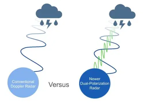
Thanks to its widespread use, Doppler radar has seen consistent technological improvements. Among the most notable advancements is the introduction of Dual-Polarization (Dual-Pol) technology.
Traditional Doppler systems use horizontally polarized radio waves, limiting them to a one-dimensional analysis of precipitation. In contrast, dual-pol radars emit both horizontally and vertically polarized pulses, capturing two-dimensional data about precipitation and cloud particles.
Understanding the Different Weather Radar Bands
Recognizing the various weather radar bands is essential, as each functions within a unique range of wavelengths and frequencies. These differences influence how each band performs, with specific strengths and limitations that determine their ideal applications in weather monitoring and forecasting.
What Is S-Band Radar?
S-Band radar operates within the 2 to 4 gigahertz (GHz) frequency range and is recognized as one of the most robust and far-reaching radar systems. Its long wavelength allows it to penetrate heavy precipitation and large storm systems, making it ideal for detecting severe weather over vast distances.
Though its resolution is moderate, it strikes a balance between range and detail, making it highly effective for a wide array of meteorological uses. Notably, the United States’ NEXRAD (Next Generation Weather Radar) system is built primarily on S-Band radar technology.
What Is C-Band Radar?
C-Band radar operates in the 4 to 8 gigahertz (GHz) frequency range and is widely utilized across various technologies, including satellite communications, select Wi-Fi networks, cordless phones, and weather monitoring systems.
Within meteorology, C-Band radar offers a practical middle ground between the long-range capabilities of S-Band and the high-resolution imaging of X-Band systems.
However, it does face notable challenges, such as signal attenuation during heavy rainfall, vulnerability to interference from terrestrial microwave links, and potential performance issues under certain atmospheric conditions.
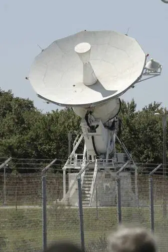
What Is X-Band Radar?
X-Band radar, known for its higher-frequency operation and shorter wavelengths, delivers exceptional sensitivity, particularly in detecting fine-scale precipitation.
This band is typically used within the 8 to 12 gigahertz (GHz) range and is commonly integrated into mobile, shipborne, and airport weather radar systems.
Its precision makes it invaluable for short-range, high-resolution weather observations, including the detection of light rain, drizzle, and localized storm structures that may not be captured by broader-band systems.
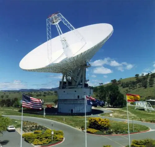
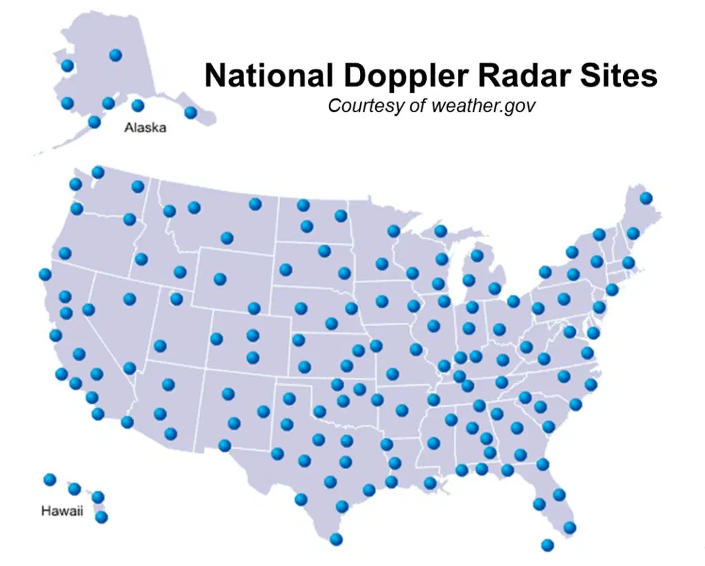
NEXRAD – America’s Advanced Public Weather Radar Network
The Next Generation Weather Radar (NEXRAD) is a highly advanced radar system managed by the National Weather Service (NWS) in the United States.
This extensive network features strategically located Doppler radar stations throughout the nation and its territories, delivering vital data for real-time weather monitoring and forecasting.
NEXRAD radars function by transmitting bursts of electromagnetic energy and analyzing the returned signals to identify precipitation, monitor storm development, and assess wind speed and direction.
As a critical tool in modern meteorology, NEXRAD significantly enhances the accuracy and timeliness of severe weather alerts and forecasts.
Limitations in Low-Level Radar Coverage
Although NEXRAD has significantly improved weather forecasting capabilities, it does have notable constraints—especially in detecting low-level atmospheric activity.
These limitations arise from the geographic spacing and elevation of radar installations, which result in blind spots or reduced sensitivity near the surface.
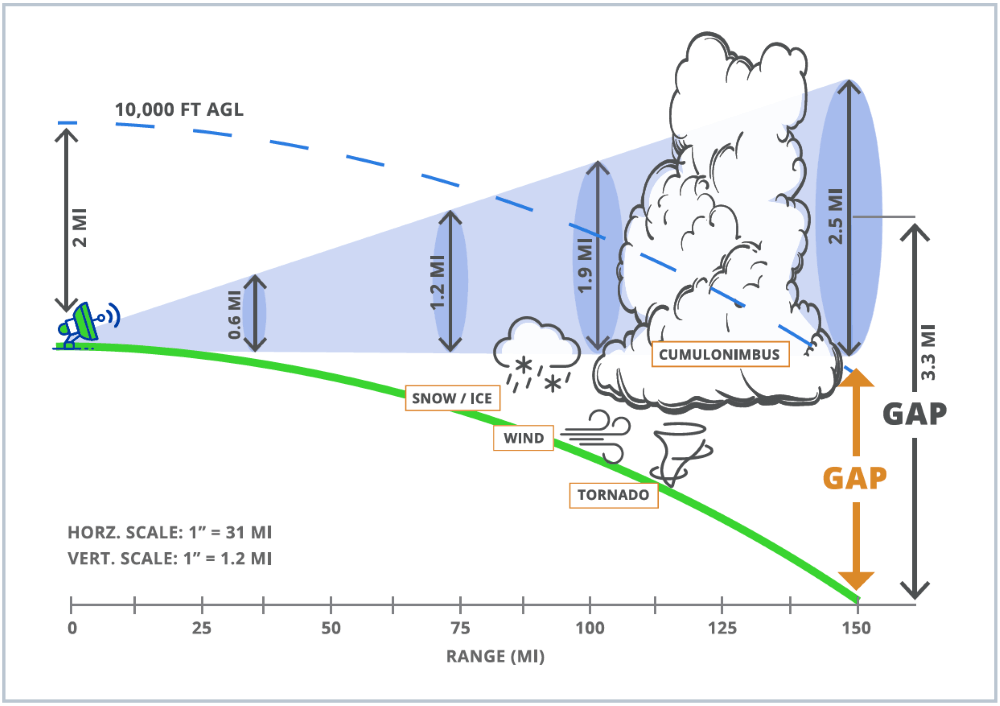
As the radar beam travels outward, Earth’s curvature causes it to rise higher above ground level, leaving substantial portions of the atmosphere below approximately 4,600 feet undetected.
Additionally, terrain features such as mountains or large structures can obstruct the radar signal, creating further coverage voids in these lower atmospheric layers.
Low Level Radar Coverage Void Consequences
Low-level radar coverage voids can significantly impact the effectiveness of weather monitoring and public safety responses.
When radar systems are unable to detect atmospheric activity below certain altitudes—typically under 4,600 feet due to Earth’s curvature or terrain obstructions like mountains—critical weather phenomena can go unnoticed.
This includes the early development of tornadoes, intense but localized thunderstorms, or downbursts that pose serious threats to life and property.
These blind spots can also hinder accurate detection of low-level precipitation, reducing the reliability of flash flood forecasting. In aviation, insufficient radar data near airports compromises the ability to monitor conditions that affect takeoffs and landings.
Furthermore, emergency response teams may lack timely, detailed information necessary for swift action, especially during rapidly evolving severe weather events. Ultimately, these radar coverage gaps can delay warnings, decrease forecast accuracy, and put communities at greater risk.
What Does It Take to Keep a Radar Network Operational?
Sustaining a weather radar network is a complex and resource-intensive endeavor, often accompanied by significant logistical, technical, and financial challenges.
Whether expanding the existing NEXRAD system or building a proprietary network from the ground up, the process demands a high level of precision, coordination, and long-term investment.Each radar installation is a custom-built project—there is no standardized blueprint.
Every site must be uniquely engineered to suit its location, ensuring both physical and remote accessibility, along with dedicated power, backup energy solutions, and secure communication links.
These foundational requirements not only incur considerable capital costs but also necessitate deep expertise across multiple disciplines, including radar science, engineering, and telecommunications.Once deployed, the work is far from over.
A robust radar network must function continuously—24/7, 365 days a year—making it far from a “set-it-and-forget-it” operation. A dedicated team of radar scientists, engineers, program managers, and technologists must actively monitor each system to ensure optimal data quality and performance.
Sophisticated automated systems further support this effort, providing real-time alerts on critical parameters like voltage levels, temperature fluctuations, and data throughput.
What’s Required to Keep a Weather Radar Network Running Smoothly?
Operating and maintaining a weather radar network is a demanding task that involves considerable technical complexity, financial investment, and organizational coordination.
Whether the goal is to enhance the current NEXRAD infrastructure or to construct a private radar network from the ground up, the process requires meticulous planning, expert knowledge, and long-term resource allocation.
Each radar installation is entirely bespoke—no two setups are alike. Sites must be designed with their unique environment in mind, requiring reliable access (both in-person and remote), primary and redundant power systems, and secure communication pathways.
These elements come with high installation costs and require a multidisciplinary approach, drawing on radar technology, electrical and civil engineering, and systems integration expertise.
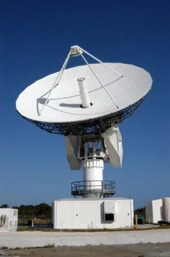
Elevating X-Band Radar Technology
As previously noted, X-Band radar comes in various forms, each with its own advantages and drawbacks. Climavision enhances X-Band radar capabilities by leveraging deep radar expertise and cutting-edge algorithmic innovations in weather science and technology, setting a new standard for precision and performance.
Advanced Weather Detection Capabilities
Although X-band systems may experience brief attenuation during intense convective weather due to their shorter wavelengths, Climavision’s proprietary system utilizes advanced scientific algorithms to mitigate this issue.
Our network has demonstrated its effectiveness across a range of weather events, including severe storms, wind phenomena, snowstorms, and even fire conditions.
The Power of High-Resolution Imaging
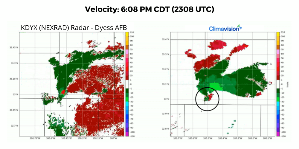
Climavision’s dual-polarization X-band systems stand out for their ability to detect and visualize weather events with ten times the resolution of traditional S-Band systems.
This high resolution is crucial for observing and understanding weather conditions closer to the ground, where atmospheric dynamics can be more volatile. Our radars are specifically designed to focus on these lower levels, providing a sharp, detailed image of near real-time conditions.
Thanks to the sensitivity of Climavision’s X-band system, clients can observe phenomena like smoke and light snow—events often missed by conventional weather radars—enabling more accurate precipitation rate measurements and improved forecasting capabilities.
Engineered to Bridge Coverage Gaps
While numerous small-scale, localized X-band radars are available for industries like marine, drone, and aviation to address immediate weather challenges, Climavision’s radars take a broader, more strategic approach.
Our large-scale X-band systems are specifically designed to fill the significant coverage gaps between NEXRAD systems, providing comprehensive, far-reaching coverage.
With a 60-mile radius, Climavision radars extend well beyond their local area, seamlessly linking with the nearest NEXRAD radar scan to ensure continuous and complete coverage.
Sustainability in Design
Unlike many traditional radar systems that rely on large transmitters like magnetrons, Climavision employs a solid-state transmitter in its proprietary system. This modern, sustainable technology offers several advantages: it’s more stable, redundant, and energy-efficient than older radar designs.
Much like how LED bulbs are a greener alternative to incandescent lights, our solid-state transmitter ensures a more eco-friendly and power-conscious solution compared to conventional radar technology.
Expanding the View from Above
At Climavision, we believe in enhancing the overall weather radar landscape, not competing with it. We understand that having more eyes in the sky leads to a clearer, more accurate picture of weather patterns. That’s why our system is designed to complement, not replace, the NEXRAD network.
By filling coverage gaps and extending radar reach, Climavision’s radars add an extra layer of reliability. Every time we activate a new radar in an underserved area, we see tangible improvements.
Together, the public NEXRAD system and Climavision’s advanced technology provide a comprehensive view of the weather, while our systems also serve as a reliable backup when NEXRAD undergoes maintenance.
Enhanced Coverage Where It’s Needed Most
Upon the full deployment of Climavision’s radar network, our Radar Scientists project a significant improvement in weather detection capabilities. Tornado detection, for example, is expected to rise from 30% to 60%, allowing for more timely and accurate warnings.
Our analysis also reveals that approximately 30% of tornado-related fatalities have occurred in areas lacking sufficient low-level radar coverage—coverage gaps that Climavision is actively addressing.
In addition, our radar systems are poised to improve the detection of high winds, with estimates showing an increase from 34% to 62%. Other key weather phenomena, such as hail size, hurricane precipitation, and rain and snowfall rates, will also see enhanced accuracy, enabling better forecasts and improved public safety.
Affordable Weather Data Without the Heavy Infrastructure Costs
One of the primary barriers for many communities seeking reliable radar systems is the significant cost involved. Traditional radar systems, such as the S-band radars in the NEXRAD network, require substantial upfront investments, often running into the millions of dollars.
In addition to the installation expenses, ongoing maintenance and operational costs, supported by dedicated National Weather Service offices, can be a financial strain.Climavision offers a more efficient solution by providing weather data through our subscription-based service, Radar as a Service (RaaS).
With RaaS, communities and organizations gain access to critical weather data without the need for costly radar installations.
This model allows clients to receive essential weather insights via an affordable annual contract, eliminating the financial burden of radar acquisition and long-term maintenance, while ensuring reliable, real-time weather information.
Real-Time Insights at Your Fingertips
Climavision enhances the accessibility and usability of weather data with advanced visualization techniques and intuitive interfaces, enabling users to make informed decisions quickly and effectively. Our Radar as a Service (RaaS) provides customizable data delivery, ensuring that organizations can access weather information in the format that best suits their needs.
DOCK:
The DOCK serves as a secure connection hub to Climavision’s extensive data lake, offering deeper, more tailored integrations to support mission-critical operations and time-sensitive tasks.
With our APIs, users can seamlessly integrate weather data into existing systems, empowering businesses to make data-driven decisions and gain valuable insights with ease.

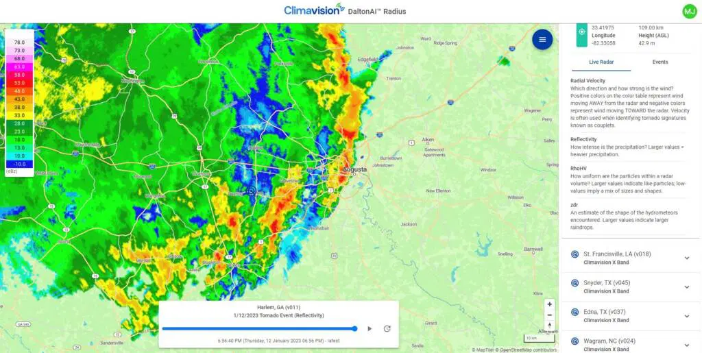
RADIUS:
RADIUS is a cutting-edge, cloud-optimized radar viewing platform that allows clients, partners, and emergency managers to access near real-time data from multiple radars.
Through RADIUS, users can stay informed as events unfold, viewing high-resolution data from Climavision’s X-Band radars alongside data from the NEXRAD network, all in one place.
Frequently Asked Questions (FAQs)
What is Climavision’s Radar as a Service (RaaS)?
RaaS is a subscription-based service that provides access to Climavision’s weather radar data without the need for expensive radar infrastructure. It allows organizations to access real-time, high-resolution weather information through a simple, cost-effective contract.
How does Climavision’s radar network enhance weather detection?
Climavision’s radar network, particularly its X-Band systems, provides high-resolution weather data, filling gaps in coverage left by larger systems like NEXRAD. This leads to improved detection of weather events like tornadoes, high winds, hail, and more, enhancing forecasting accuracy.
What types of weather phenomena does Climavision’s radar network detect?
Climavision’s radar network can detect a wide range of weather events, including tornadoes, high winds, snowstorms, hail, precipitation rates, and other meteorological phenomena. Its high resolution also allows for more detailed measurements, such as hail size and precipitation accumulation.
How does the DOCK work?
The DOCK is a secure connection point to Climavision’s vast data lake. It enables deeper integrations for business-critical operations and time-sensitive tasks. Through APIs, the DOCK allows seamless access to weather data and supports customized visualizations within existing platforms.
What is RADIUS?
RADIUS is a next-generation, cloud-optimized application that allows users to view weather data from multiple radars in near real-time. It provides high-resolution weather information from both Climavision’s X-Band radars and the NEXRAD network, helping users stay informed as events unfold.
Can Climavision’s radar network be integrated into existing weather systems?
Yes, Climavision’s radar data and APIs are designed for easy integration into existing weather systems and platforms. This flexibility allows organizations to leverage real-time data within their current operations.
Conclusion
Climavision is revolutionizing the way weather data is accessed and utilized with its innovative radar systems and services. Through its advanced network of high-resolution X-Band radars and the efficient Radar as a Service (RaaS) model, Climavision is filling critical gaps in weather coverage, providing real-time, accurate data that enhances weather forecasting and decision-making.