

Volcanic eruptions pose significant threats to aviation, primarily through the presence of ash clouds that can severely disrupt flight operations. These ash clouds contain fine particles that, when inhaled by aircraft engines, can cause engine failure and compromise flight safety.
As a result, real-time forecasting tools have become essential in improving both volcanic ash management and aviation safety.
By providing accurate predictions of ash plume movement and concentration, these tools allow airlines and air traffic controllers to make informed decisions, reroute flights, and implement safety measures effectively.
This proactive approach minimizes the risk to aircraft, ensures safer travel, and helps maintain the flow of air traffic during volcanic events. Enhancing forecasting tools continues to be critical for aviation safety in volcanic regions.
Read More: Enhancing Aviation Safety and Volcanic Ash Management with Real-Time Forecasting Tools
The Operational Risks of Volcanic Ash
Volcanic ash presents significant hazards to aviation, with the potential to cause severe damage to aircraft engines and other critical systems.
The abrasive nature of the ash particles can erode engine components, and when they enter the combustion chambers, they can melt, leading to blockages that may result in catastrophic engine failure.
Beyond engine damage, volcanic ash can also disrupt navigation systems, obscure windshields, and severely reduce visibility, increasing the overall risk of flying through affected airspace.

To mitigate these risks, airlines often must reroute flights, delay departures, or cancel operations altogether, causing costly disruptions. To minimize the impact on both passengers and flight schedules, airlines and air traffic controllers rely on accurate, real-time information to make informed decisions and ensure safe air travel.
Comprehensive Forecasting for Aviation Safety
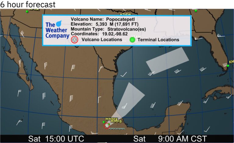
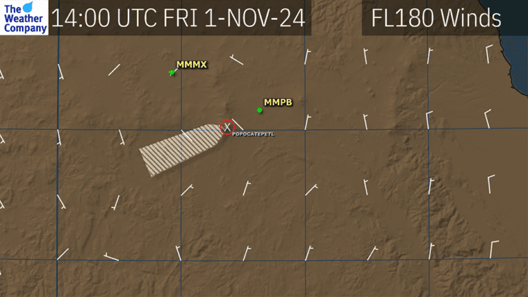
Volcanic Ash Forecast Flight Plan Guidance (FPGs) provides critical insights into the anticipated path of volcanic ash over time, using flight-level winds that correspond to the ash’s altitude. This forecast assumes that ash concentrations are high enough to prevent diffusion as the ash traverses airspace.
Additionally, it assumes ongoing emissions directly from the volcano for forecasts extending from the summit.To address the complexities of volcanic ash hazards, The Weather Company offers advanced tools, including the Enroute Hazards package, designed to enhance aviation safety across all operational levels.
In addition to basic Volcanic Ash Advisory Center (VAAC) bulletins, our services include detailed volcanic ash SIGMET (Significant Meteorological Information) alerts.
These notifications are triggered when ash reaches critical thresholds—such as 6,000 feet above a summit or 10,000 feet above ground level, and extends beyond 50 nautical miles. SIGMETs are also issued for enhanced safety when ash is detected near key destinations, even if these thresholds are not met.
Real-Time Monitoring and Advanced Tools
Monitoring volcanic ash in real-time presents a complex challenge, but The Weather Company offers sophisticated tools to ensure precise tracking.
Using RGB satellite imagery from GOES-East and GOES-West satellites, we provide highly accurate identification and monitoring of volcanic ash, even under challenging weather conditions.
Techniques such as channel differencing with the ash-sensitive 8.4-micron channel allow forecasters to effectively distinguish volcanic ash from other atmospheric elements like steam or water vapor.
To enhance these forecasts, The Weather Company also integrates third-party webcams for real-time visual monitoring of volcanic activity.
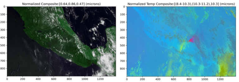
These webcams offer continuous views of active volcanoes, such as Mexico’s Popocatépetl, enabling forecasters to differentiate between ash emissions and less hazardous steam or gas.
By combining satellite imagery with real-time webcam data, this comprehensive monitoring system empowers airline operations teams to make well-informed decisions, improving overall safety and efficiency.
Ash Forecast Modeling
For significant volcanic eruptions, The Weather Company utilizes advanced ash forecast modeling to predict the dispersion of ash through the atmosphere.
These forecasts are generated using GFS-based weather models, which factor in jet streams and other atmospheric conditions to predict the movement and behavior of ash clouds in relation to flight paths.
This sophisticated modeling is essential for large eruptions, where ash can remain in the atmosphere for days or even weeks, creating prolonged risks for aviation.For smaller ash emissions, established patterns of ash movement provide valuable guidance for decision-making.
However, for larger eruptions, detailed forecasts on ash dispersion offer airlines crucial information regarding ash locations and their projected paths, enabling them to effectively plan for both immediate and long-term impacts.
Potential Volcanic Ash Impact Reports
The Potential Volcanic Ash Impact Report is an essential tool for aviation planning, providing daily updates on volcanic ash movement, especially for airports located near active volcanoes.
Airports close to volcanoes like Popocatépetl, Fuego, and Sangay receive real-time information on the potential direction and movement of ash clouds toward key airspace and terminals.
While these reports do not forecast explosive eruptions, they offer valuable insights into how ongoing volcanic emissions might affect nearby aviation operations.These reports are crucial for maintaining situational awareness, particularly for airports operating in regions with frequent volcanic activity.
By delivering advanced notice of potential ash impacts, the reports enable airports and airlines to make informed, proactive decisions, minimizing the risk of unexpected disruptions and enhancing operational efficiency.
Human-Over-the-Loop Reports for Comprehensive Insights
Gain confidence in navigating volcanic ash hazards with The Weather Company’s detailed Human-Over-the-Loop (HOTL) Reports. These reports consolidate critical volcanic ash data into easy-to-read PDFs, featuring key elements such as SIGMETs, wind barbs, and satellite imagery.
This consolidated information provides airlines with a comprehensive view of the current volcanic activity, empowering them to make more informed decisions regarding flight safety and route planning.
By bringing all relevant data together in one place, HOTL reports offer real-time insights into volcanic hazards. Operational leaders can quickly assess the situation and take prompt, strategic action to adjust flight operations, minimizing risks and ensuring the safety of passengers and crew.
Staying Ahead with Proactive Volcanic Ash Forecasting
Volcanic ash poses serious risks to aviation, but these challenges can be effectively managed with proactive planning and real-time insights.
The Weather Company’s suite of forecasting solutions equips airlines with the tools needed to anticipate disruptions, enabling decision-makers to maintain safe and efficient operations, even in unpredictable conditions.
With seamless integration into existing operational workflows, The Weather Company’s forecasting services require minimal effort to implement, allowing airlines to quickly harness this vital technology.
Don’t let volcanic ash jeopardize your operations. Enhance your airline’s safety and efficiency with The Weather Company’s industry-leading Weather Forecast Services.
Frequently Asked Questions (FAQs)
What is volcanic ash, and why is it dangerous for aviation?
Volcanic ash consists of fine particles ejected during an eruption. These particles can damage aircraft engines, affect visibility, and disrupt flight navigation, making them hazardous to aviation safety.
How does volcanic ash affect aircraft engines?
Volcanic ash is abrasive and can melt inside an aircraft’s engine, causing blockages, damage to the combustion chambers, and, in some cases, engine failure. The particles can also affect the aircraft’s air filtration system.
What tools does The Weather Company offer to help airlines manage volcanic ash hazards?
The Weather Company provides advanced forecasting tools, including real-time monitoring, ash dispersion models, and detailed Human-Over-the-Loop (HOTL) reports that integrate seamlessly into operational workflows, enabling airlines to make informed decisions.
How does volcanic ash forecasting work?
Forecasts are generated using sophisticated models that account for atmospheric conditions, such as jet streams, wind patterns, and volcanic activity. This allows airlines to track the movement of ash clouds and adjust flight plans accordingly.
Are there any real-time tools available to track volcanic ash?
Yes, The Weather Company offers tools such as RGB satellite imagery and third-party webcam data to provide real-time monitoring of volcanic ash, helping airlines make timely decisions based on the most current data.
What are the potential impacts of volcanic ash on airports?
Airports located near active volcanoes are at risk of ash cloud disruptions. The Weather Company’s daily volcanic ash impact reports help these airports monitor potential ash movement, allowing for proactive adjustments to minimize disruptions.
Conclusion
Volcanic ash poses significant challenges to aviation safety, but with the right tools and proactive planning, these risks can be effectively managed. The Weather Company offers advanced forecasting solutions that provide real-time insights, precise ash tracking, and detailed reports, allowing airlines to make informed decisions and take timely actions.