
")
Coastal inundation poses a growing risk to densely populated, low-lying coastal regions, challenging scientists and policymakers across meteorology, hydrology, oceanography, and emergency management.
In response, the World Meteorological Organization (WMO), through its former commissions JCOMM and CHy, launched the Coastal Inundation Forecasting Demonstration Project (CIFDP) in 2009.
CIFDP aimed to enhance national forecasting and warning systems by fostering science-based, user-focused solutions to mitigate the impacts of storm surges, extreme waves, and river flooding.
Endorsed by the WMO Executive Council, CIFDP emphasized stakeholder collaboration, technology transfer, and operational sustainability.
Its approach supported national coordination, regional scalability, and integration with existing initiatives like the Severe Weather Forecasting Demonstration Project, ultimately strengthening coastal resilience through informed, multi-hazard risk management.
Read More: Coastal Inundation Forecasting Pilot Program (CIFDP)
Casualties by Cyclones and Storm Surges
Cyclones and storm surges are among the deadliest natural hazards affecting coastal regions worldwide. These events often lead to significant loss of life, primarily due to rapidly rising waters, extreme winds, and inadequate early warning systems.
Storm surges, in particular, can inundate vast low-lying areas, catching vulnerable populations off guard—especially in regions with limited evacuation infrastructure or public awareness.
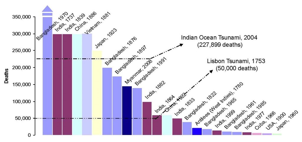
Historically, some of the highest death tolls from natural disasters have been caused by tropical cyclones and their associated surges, such as the 1970 Bhola cyclone in Bangladesh, which claimed hundreds of thousands of lives.
While advancements in forecasting and emergency response have reduced fatalities in recent years, the risk remains high, especially in developing nations with densely populated coastal zones.
Global Distribution of Flood Risk (Mortality)
Flood-related mortality is unevenly distributed across the globe, with the highest risks concentrated in low- and middle-income countries, particularly in South and Southeast Asia, sub-Saharan Africa, and parts of Central and South America.
These regions often face a combination of dense populations in flood-prone areas, limited infrastructure, inadequate early warning systems, and constrained emergency response capacity.
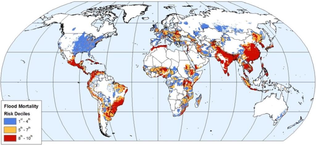
Coastal and riverine flooding, intensified by climate change, urbanization, and land degradation, disproportionately affect vulnerable communities, leading to higher casualty rates.
Conversely, high-income countries typically experience lower flood mortality due to advanced forecasting technology, well-maintained infrastructure, and effective disaster management systems.
Addressing global flood risk requires a focused effort on capacity-building, investment in resilient infrastructure, and inclusive planning in the most at-risk regions.
Global Distribution of Cyclone Risk (Mortality)
The global distribution of cyclone-related mortality reveals stark regional disparities, with the greatest loss of life occurring in tropical and subtropical coastal regions, particularly in South Asia, Southeast Asia, and parts of the Caribbean.
Countries like Bangladesh, India, the Philippines, and Haiti have historically suffered the highest cyclone death tolls, often due to densely populated coastal areas, limited disaster preparedness, and socio-economic vulnerability.
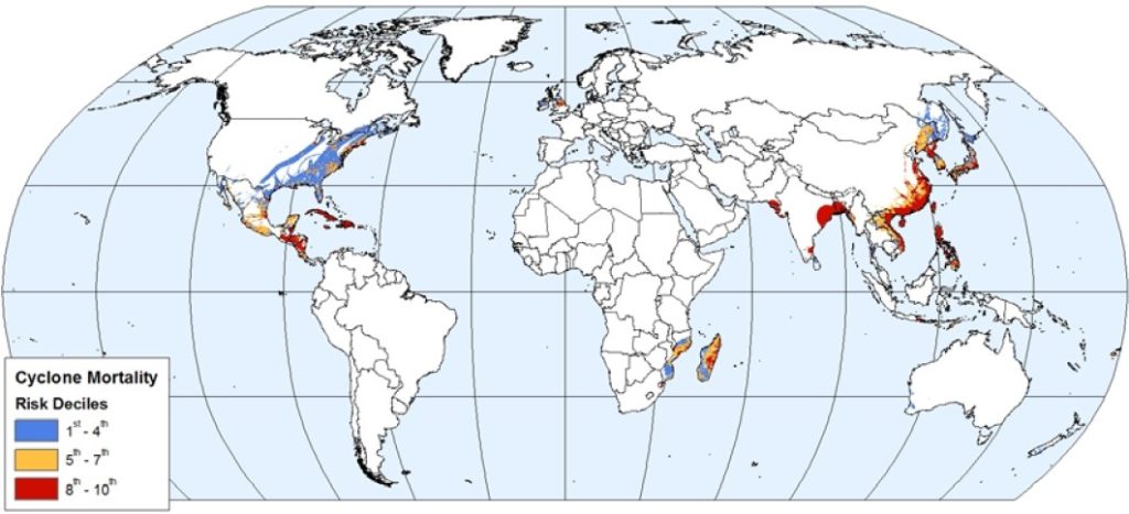
These regions frequently experience powerful tropical cyclones that bring destructive winds, storm surges, and flooding. In contrast, wealthier nations such as the United States and Australia, while also exposed to severe cyclones, tend to record significantly lower mortality due to robust early warning systems.
Strict building codes, and efficient evacuation protocols. Reducing global cyclone mortality requires targeted investment in risk reduction strategies, particularly in high-risk, low-resource settings.
Objectives and Scope
The Coastal Inundation Forecasting Demonstration Project (CIFDP) was established with the primary objective of enhancing the operational capabilities of national agencies to deliver timely, accurate, and actionable coastal flood forecasts and warnings.
Beyond improving forecast precision, the project sought to bridge the gap between scientific innovation and real-world application, ensuring that coastal risk management strategies are both technically sound and community-focused.
A key objective was to foster regional cooperation and knowledge sharing by creating scalable forecasting models adaptable to local conditions. The scope of CIFDP extends beyond meteorological modeling—it integrates hydrological, oceanographic, and socio-economic dimensions to support multi-hazard early warning systems.
This holistic approach empowers national agencies to build sustainable systems tailored to protect vulnerable coastal populations from the growing threat of inundation.
Expected Outcome and Deliverables
The Coastal Inundation Forecasting Demonstration Project (CIFDP) aims to deliver a robust, end-to-end coastal inundation forecasting and warning framework that is both operational and sustainable within national systems.
A key expected outcome is the establishment of a fully functional, user-driven forecasting model tailored to specific national or regional conditions. This includes the integration of atmospheric, oceanic, and hydrological data streams into a seamless forecasting system.
Deliverables include a set of standard operating procedures for coastal hazard response, capacity-building workshops, stakeholder engagement protocols, and a technical toolkit for implementation and training.
Additionally, the project will produce open-source forecasting templates and documentation that can be transferred and adapted by other at-risk countries, thus supporting regional harmonization and long-term disaster resilience planning.
Strategic Approach for Project Implementation
The strategic approach of the Coastal Inundation Forecasting Demonstration Project (CIFDP) centers on a phased, stakeholder-driven implementation model that ensures both national ownership and long-term sustainability.
The project is initiated through the formation of a National Coordination Team (NCT), comprising representatives from meteorological, hydrological, oceanographic, disaster management, and planning agencies.
This team leads the design and customization of the forecasting system based on locally identified risks and user requirements. A critical component of the strategy is the “cascading forecasting framework,” which links global and regional guidance to national and community-level decision-making.
By leveraging open-source technologies and existing infrastructure, CIFDP ensures cost-effectiveness and adaptability. Furthermore, the approach emphasizes iterative learning, capacity-building, and cross-sector collaboration to integrate scientific models into practical emergency response operations.
National Commitment
National commitment is the cornerstone of the Coastal Inundation Forecasting Demonstration Project (CIFDP), ensuring that the forecasting and warning systems developed are not only technically sound but also politically and institutionally sustainable.
Participating countries are required to demonstrate strong inter-agency collaboration through formal agreements among meteorological, hydrological, disaster management, and coastal planning institutions.
This commitment includes the establishment of a National Coordination Team (NCT) to oversee project activities, allocate national resources, and integrate the system into existing governance frameworks.
Furthermore, national agencies are expected to maintain and operate the forecasting tools beyond the demonstration phase, highlighting the importance of institutional ownership. Through this commitment, CIFDP fosters national resilience, accountability, and the embedding of coastal risk management into long-term development and climate adaptation strategies.
CIFDP Project Implementation
The CIFDP is structured to be implemented in a phased approach, ensuring adaptability to each region’s specific needs and requirements. This process allows for the integration of new data, lessons learned, and technological advancements as the project progresses.
Project Preparation
The first phase, known as Project Preparation, focuses on political and institutional alignment. Prior to launching the CIFDP, initial national agreements must be reached at the political level.
This step defines the scope for national sub-projects, establishes commitment from national agencies, and ensures open data exchange to support the forecasting system’s effectiveness.
The preparation also emphasizes the need for clear coordination to facilitate long-term cooperation and successful project outcomes.
Information Gathering & Project Adaptation
In Phase 1, information gathering is paramount. This stage begins with an assessment of the nation’s existing capabilities in areas such as coastal flood risk management, inundation forecasting, and emergency response structures.
Key deliverables during this phase include the creation of the User Requirements Plan (URP), which identifies and documents the information and communication needs of stakeholders involved in emergency management.
This is followed by a Stakeholders Workshop, a milestone that serves to deepen the understanding of local needs, facilitate collaboration, and ensure alignment with project objectives.
Following this workshop, a Definitive National Agreement (DNA) is established, solidifying government commitment and defining the roles of national agencies.
The National Coordination Team (NCT) is then formed, tasked with managing the project’s implementation, ensuring coordination across agencies, and addressing gaps identified during the National Capacity Assessment (NCA).
System Implementation
Phase 2 focuses on the development and implementation of the forecasting system. It begins with a kick-off meeting to confirm the approach and system specifications.
Once the system developer(s) are selected, the process moves into system development, which includes hardware setup, , and pre-operational testing. During this phase, capacity-building efforts, such as training for system operators, ensure that the necessary skills are in place to manage the system effectively.
Additionally, user products are developed in collaboration with disaster management authorities, ensuring that the system is tailored to actual needs. As the system becomes operational, feedback from both forecasters and end-users is gathered and used to refine the system.
Pre-Operational Testing & Capacity Development
Phase 3 transitions the system towards full operational capability. This phase is critical for formalizing operational procedures, developing service products for coastal inundation management, and conducting comprehensive acceptance testing.
One of the key milestones is the simulation of an extreme inundation event, which tests the system in a real-world context. This simulation, involving all key stakeholders, helps ensure the system’s readiness for live operational use.
Alongside this, additional training materials are developed, and further capacity-building activities are carried out to strengthen the long-term sustainability of the CIFDP.
Live Running & Evaluation
In Phase 4, the CIF system is fully operational. This final phase focuses on accommodating user feedback, refining the system based on real-world usage, and ensuring ongoing support.
Regular evaluations, both national and international, are conducted to assess the system’s performance and to identify opportunities for future improvements and enhancements.
As the CIFDP reaches completion, the system is set to support the community’s ongoing disaster preparedness efforts and enhance their resilience to coastal flooding risks.
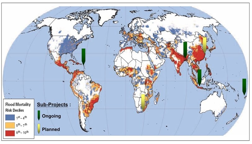
Sub-Projects in CIFDP: A Strategic Approach to Coastal Inundation Forecasting
Sub-projects within the CIFDP (Coastal Inundation Forecasting Demonstration Project) are integral to the overall success of the initiative, allowing for tailored solutions that address specific coastal flood risks and challenges across different regions or countries.
These sub-projects, while part of the broader CIFDP framework, are designed to operate independently, ensuring flexibility, focus, and customized solutions based on local conditions.
Tailored Forecasting Systems for Local Needs:
Each sub-project within the CIFDP is customized to meet the specific needs of the participating region or country. For example, a coastal region with significant urban infrastructure may require a different focus compared to rural or ecologically sensitive coastal areas.
By addressing localized needs, sub-projects ensure that the forecasting systems are relevant and directly applicable to the unique challenges of each area.
Collaboration with Local Stakeholders:
Each sub-project emphasizes collaboration with local stakeholders, including national meteorological agencies, disaster management organizations, and community representatives. This collaboration ensures that the sub-projects align with local governance structures and decision-making processes.
Stakeholder engagement is critical for the development of the User Requirements Plan (URP), which identifies specific information needs for emergency management agencies, local authorities, and the general public during extreme coastal flooding events.
Phased Implementation for Adaptability:
Sub-projects are implemented in phases, similar to the overall CIFDP, with an emphasis on continuous feedback and adaptability. This phased approach allows the project to be refined as it progresses, ensuring that lessons learned from earlier phases can be incorporated into later stages.
This adaptability makes sub-projects particularly effective in responding to changing environmental, technological, and socio-political contexts.
Capacity Building for Long-Term Sustainability:
A critical element of each sub-project is the focus on building local capacity. This includes training local staff and agencies, developing technical expertise, and strengthening institutional frameworks to ensure the continued success of coastal inundation forecasting systems after the project’s completion.
Each sub-project includes a clear plan for ongoing training, skill development, and knowledge transfer to ensure sustainability and minimize dependency on external expertise.
Multi-Agency Coordination:
Sub-projects require strong coordination across various national and regional agencies. By forming a National Coordination Team (NCT) for each sub-project, the CIFDP ensures that all relevant agencies work together towards a unified goal.
The NCT is responsible for managing the sub-project’s implementation, ensuring that all stakeholders are aligned and that the project is progressing according to plan. Additionally, cooperation with regional and international agencies may be involved, particularly when cross-border flood risks or shared coastal zones are concerned.
Frequently Asked Questions (FAQs)
What is CIFDP?
CIFDP stands for the Coastal Inundation Forecasting Demonstration Project. It is a global initiative designed to improve the forecasting and warning systems for coastal inundation events, such as flooding due to cyclones, storm surges, and heavy rainfall.
The project aims to enhance preparedness, reduce casualties, and strengthen resilience to coastal flooding in vulnerable regions.
What are “sub-projects” in CIFDP?
Sub-projects are specific, localized initiatives within the broader CIFDP framework that target particular coastal regions or countries. Each sub-project is designed to meet the unique needs and challenges of that area, focusing on local capacity building, stakeholder engagement, and the development of forecasting systems.
Who are the stakeholders involved in CIFDP?
Stakeholders in CIFDP include national meteorological agencies, disaster management organizations, local governments, community representatives, technical experts, and regional or international bodies involved in coastal flood risk management. Collaboration between these groups is critical to the project’s success.
How does CIFDP ensure sustainability after the project ends?
Sustainability is a key focus of CIFDP. The project includes capacity-building efforts such as training local staff, developing technical expertise, and strengthening institutional frameworks. Additionally, the project emphasizes the creation of systems and processes that can continue to operate and improve even after external support ends.
What is the role of the National Coordination Team (NCT)?
The National Coordination Team (NCT) is responsible for managing the implementation of CIFDP at the national level. The NCT ensures that the sub-project is progressing according to plan, that all relevant agencies are involved, and that the forecasting systems are integrated into national disaster management frameworks.
How does CIFDP address local disaster management needs?
Each CIFDP sub-project includes a thorough assessment of local disaster management structures and requirements. By creating a User Requirements Plan (URP), the project ensures that the forecasting systems are designed with the specific needs of emergency response agencies and communities in mind, enhancing overall disaster resilience.
Conclusion
The Coastal Inundation Forecasting Demonstration Project (CIFDP) represents a crucial step toward enhancing global coastal resilience by providing accurate and reliable forecasting systems for coastal inundation events. Through a structured, phased approach, CIFDP aims to equip vulnerable regions with the tools and knowledge required to mitigate the impacts of coastal flooding, enhance disaster preparedness, and strengthen emergency management efforts.