
As hurricane seasons grow more unpredictable and severe, staying informed and prepared is essential for safeguarding yourself and your loved ones. Fortunately, a range of hurricane-tracking and awareness apps are available to provide real-time updates, forecasts, and safety guidance.
These tools offer features such as interactive storm tracking maps, emergency alerts, shelter locations, and preparedness checklists.
Notable apps include the FEMA App, which offers real-time weather alerts and disaster resources ; MyRadar Weather Radar, providing high-resolution radar imagery and hurricane tracking ; and the Emergency App by the American Red Cross, featuring customizable weather alerts and safety tips .
By leveraging these technologies, you can make timely decisions and enhance your readiness during hurricane season.
Read More: Top Hurricane Tracking Apps Recommended by Disaster Responders
Professional Hurricane Tracking Tools: The National Hurricane Center
For emergency management professionals and disaster response teams, the National Hurricane Center (NHC) serves as the authoritative source for hurricane tracking and forecasting. Accessible at www.nhc.noaa.gov, the NHC provides real-time updates, detailed hurricane tracking maps, and comprehensive information on current and potential tropical cyclones. Key features include wind speed probabilities, estimated arrival times of winds, wind history, and storm surge forecasts.
Alex MacInnis, a disaster response planner at Team Rubicon, emphasizes the site’s utility:
We use that website a lot to keep track of formation of hurricanes and where they’re at. They’ll post a lot of information about windspeed probabilities, arrival time of winds, the wind history—like the cones and the warning tones. Hurricane warnings and watches, storm surge, and more all come from the National Hurricane Center.
The NHC’s authoritative data serves as the foundation for many other weather platforms and applications, making it an indispensable tool for those involved in emergency preparedness and response.
Essential Hurricane Tracking Resource: The National Weather Service
In addition to the National Hurricane Center, the National Weather Service (NWS) offers a robust platform for hurricane monitoring and preparedness. Accessible at weather.gov, the NWS provides real-time updates, detailed forecasts, and localized alerts.
By entering a ZIP code on the homepage, users can receive tailored information from their local NWS office, including hurricane watches, warnings, and storm surge forecasts.
The NWS’s publicly available data is invaluable to disaster response organizations like Team Rubicon, which integrate this information into their mapping systems for effective hurricane tracking and response planning.
Baron Threat Net: A Premium Subscription-Based Hurricane Tracking Solution for Professionals
Baron Threat Net is a subscription-based weather intelligence platform tailored for emergency managers, first responders, and public safety professionals requiring precise, real-time data for critical decision-making.
Accessible via web browsers and mobile devices, it delivers high-resolution radar imagery, patented storm tracking, and hyperlocal forecasts to support proactive disaster response.
The platform’s proprietary tools, such as Baron Storm Vectors, provide detailed insights into severe weather threats, including tornadoes, hail, and high winds. These features enable users to project storm movements up to an hour in advance, facilitating timely and informed responses.
Baron Threat Net’s customizable alert system allows users to set specific thresholds for various locations, ensuring that critical weather alerts are received promptly via text, email, or in-app notifications. This feature enhances situational awareness and supports effective coordination during severe weather events.
Trusted by numerous emergency management agencies and organizations, Baron Threat Net’s user-friendly interface and comprehensive data make it an indispensable tool for professionals tasked with safeguarding communities during severe weather events.
The Best Hurricane Tracking Apps
Clime: NOAA Weather Radar Live – Your Comprehensive Hurricane Tracking Companion
Clime: NOAA Weather Radar Live is a powerful weather application that provides real-time radar imagery, detailed weather maps, and timely alerts for severe weather conditions, including hurricanes. Developed by Apalon Apps, this app leverages data from the National Oceanic and Atmospheric Administration (NOAA), ensuring users receive accurate and up-to-date information.
Key Features:
Real-Time Radar Imagery: Clime offers high-resolution radar images that display areas of rain, snow, and mixed precipitation. Users can view animated radar loops to track storm movements over the past 40 minutes, aiding in forecasting and preparedness.
Hurricane Tracker: The app includes a dedicated Hurricane Tracker that allows users to monitor the current position and projected path of hurricanes. It provides timely alerts and updates, helping users stay informed about potential threats.
Customizable Alerts: Users can set up push notifications for various weather events, such as hurricanes, tornadoes, and freeze warnings, for their saved locations. This feature ensures that users receive immediate notifications about severe weather conditions.
Interactive Maps: Clime provides interactive maps that display National Weather Service watches, warnings, and alerts in the form of polygons. Users can tap on these areas to view detailed alert information, enhancing situational awareness.
Additional Weather Data: The app offers precipitation and temperature forecasts, satellite imagery, and cloud cover maps. It also includes a 14-day hourly forecast, snow depth forecasts, and pollen data, providing comprehensive weather information.
American Red Cross Emergency App: Your Essential Disaster Preparedness Tool
The American Red Cross Emergency App is a comprehensive, free mobile application designed to help individuals and families prepare for, respond to, and recover from various emergencies. Available in English and Spanish, the app offers real-time alerts, safety information, and tools to stay informed during disasters.
Key Features:
Customizable Alerts: Users can set up to 40 different weather and emergency alerts, including hurricanes, tornadoes, earthquakes, and floods, tailored to their locations. The app overrides the phone’s “Do Not Disturb” mode for critical notifications.
Interactive Maps: The app provides interactive maps to locate open Red Cross shelters and track real-time weather conditions, helping users find safe havens during emergencies.
Safety Information and Preparedness Tools: It offers step-by-step guides for disaster preparedness, including emergency kits, evacuation plans, and first aid instructions. Preloaded content ensures access to vital information even without internet connectivity.
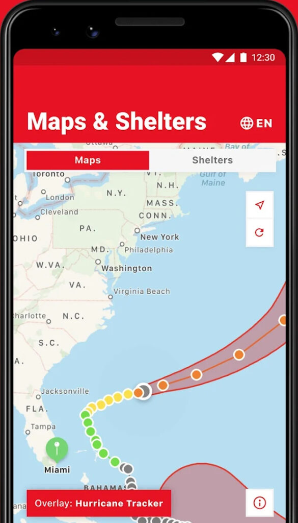
“I’m Safe” Feature: This feature allows users to notify family and friends of their safety via social media or email, providing peace of mind during crises.
Accessibility Features: The app includes accessibility options to ensure that individuals with disabilities can access critical information during emergencies.
The FEMA App: Your Essential Disaster Preparedness Tool
The FEMA App is a comprehensive mobile application developed by the Federal Emergency Management Agency to assist individuals and families in preparing for, responding to, and recovering from disasters. This free app provides real-time alerts, safety information, and resources to help users navigate emergencies effectively.
Key Features:
Real-Time Alerts: Receive timely weather and emergency alerts from the National Weather Service for up to five locations nationwide. This feature ensures that users stay informed about potential hazards affecting areas they care about.
Shelter Locator: The app helps users find nearby shelters during emergencies. By texting “SHELTER” followed by a ZIP code to 43362, individuals can receive a list of available shelters within a 200-mile radius. This service is available across all 50 states and U.S. territories.
Preparedness Guidance: Access clear and concise information on how to prepare for various disasters. The app offers guidance on creating a family emergency communication plan, building an emergency kit, and understanding immediate steps to take during different types of emergencies.
Disaster Recovery Assistance: Find answers to frequently asked questions about the disaster assistance process and locate FEMA Disaster Recovery Centers nearby. This feature provides users with the tools they need to recover after a disaster.
Accessibility Features: The FEMA App is compatible with screen reader technology and adheres to federal accessibility standards. It includes inclusive design principles such as consistent user interfaces, plain language, and ALT text descriptions, ensuring that all individuals can access critical information during emergencies.
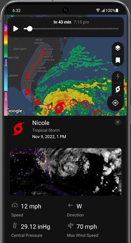
My Hurricane Tracker & Alerts: A Comprehensive Storm Tracking Tool
My Hurricane Tracker & Alerts is a comprehensive mobile application developed by JRustonApps B.V. to assist users in tracking hurricanes, tropical storms, tornadoes, and other severe weather events. This free app offers a user-friendly interface that provides essential weather data without overwhelming users with cluttered screens.
Key Features:
Interactive Tracking Maps: The app provides detailed maps for each storm, allowing users to visualize the storm’s path and intensity.
NOAA Forecast Maps & Satellite Imagery: Access to National Oceanic and Atmospheric Administration (NOAA) forecast maps and satellite imagery helps users stay informed about current and potential storm developments.
Historical Storm Data: Users can explore past storms dating back to 1851 in the Atlantic and 1949 in the Pacific, providing valuable insights into historical storm patterns.
Weather Warnings & Notifications: Receive timely weather warnings from the National Weather Service, along with push notifications for new storm formations or updates.
Radar, Satellite & Sea Temperature Images: The app automatically updates radar, satellite, and sea temperature images, ensuring users have the latest information at their fingertips.
Tropical Hurricane Tracker: A Comprehensive Storm Monitoring Tool
The Tropical Hurricane Tracker app offers real-time information on hurricanes, tropical storms, and disturbances across the Atlantic, Central Pacific, and Eastern Pacific basins. Designed for clarity and ease of use, it provides users with a streamlined interface to access essential storm data without unnecessary complexity.
Key Features:
Regional Tracking Maps: View detailed maps for each storm, tailored to specific regions, to monitor their paths and potential impacts.
NOAA Forecasts: Access up-to-date forecasts from the National Oceanic and Atmospheric Administration to stay informed about storm developments.
Interactive Global Map: Explore a global map to understand the broader context of storm movements and related weather patterns.
Push Notifications: Receive timely alerts about significant weather events and changes in storm conditions.
Ensemble Models: Utilize ensemble forecasting models to assess a range of possible storm scenarios and outcomes.
Leveraging Social Media for Enhanced Hurricane Tracking and Community Response
In the digital age, social media platforms have become invaluable tools for real-time hurricane tracking and community engagement. Beyond traditional meteorological updates, platforms like Twitter, Facebook, Instagram, and TikTok offer unique insights into storm developments and local impacts.
Real-Time Updates and Community Insights
Twitter serves as a dynamic platform for disseminating official updates from agencies such as the National Hurricane Center (@NWSNHC), FEMA (@fema), and NOAA Hurricane Hunters (@NOAA_HurrHunter). These accounts provide timely information on storm paths, warnings, and preparedness tips. Additionally, users can monitor hashtags like #hurricane or #stormwatch to access firsthand reports and imagery from affected areas.
For instance, disaster responders often utilize Twitter to assess damage reports and identify areas in need of assistance. By searching for location-specific terms combined with “WX” (e.g., “WXHouston”), responders can quickly gather information on current conditions and recent damage reports.
Innovative Uses of Social Media in Disaster Response
Organizations like Team Rubicon have adopted creative approaches to utilizing social media for disaster response. During recovery efforts, they turn to platforms like Snapchat to access the “Snap Map,” where users may post photos and requests for help. This real-time visual data aids responders in identifying areas requiring immediate attention.
Cautions and Best Practices
While social media provides valuable information, it’s essential to verify the credibility of sources before acting on shared content. Official accounts and verified organizations should be prioritized for accurate updates. Additionally, users should be cautious of misinformation and refrain from sharing unverified content that could cause unnecessary panic.
Frequently asked questions(FAQs)
What is a hurricane tracking app?
A hurricane tracking app is a mobile application that provides real-time updates and detailed information about hurricanes, including their path, strength, and projected impact. These apps help users stay informed and prepared for severe weather events.
Why are hurricane tracking apps important?
These apps allow users to receive timely updates on hurricanes, monitor their progress, and make informed decisions. This is especially crucial for individuals in areas prone to hurricanes, as it aids in evacuations and preparations for the storm.
Are these apps available for both Android and iOS?
Yes, most of the top hurricane tracking apps are available on both Android and iOS platforms.
Do these apps work offline during a storm?
Some apps, like FEMA and AccuWeather, offer offline access to certain information, such as emergency plans and previous forecasts. However, live tracking and updates typically require an internet connection.
How accurate are the forecasts on these apps?
The accuracy of the forecasts depends on the app’s data sources, which typically come from NOAA (National Oceanic and Atmospheric Administration) and other meteorological organizations. While the apps aim to provide real-time, reliable updates, the unpredictability of hurricanes can sometimes lead to changes in their path and intensity.
Conclusion
When it comes to preparing for hurricanes and staying informed during a storm, having access to accurate, real-time information is crucial. The top hurricane tracking apps recommended by disaster responders, such as The Weather Channel, Hurricane Tracker, MyRadar, AccuWeather, and FEMA, provide essential tools for tracking storms, receiving alerts, and accessing emergency resources.