

Tornadoes swept across parts of Missouri and Mississippi over the weekend, compounding the devastation already caused by deadly dust storms and wildfires that recently tore through the central Plains.
The violent twisters uprooted trees, destroyed homes, and knocked out power to thousands, leaving residents scrambling for shelter and safety. Just days earlier, intense winds fueled fast-moving wildfires and blinding dust storms across Kansas, Nebraska, and Oklahoma, claiming lives and forcing mass evacuations.
Emergency crews are now working around the clock to assess the damage and aid displaced families. With extreme weather becoming more frequent, officials are urging communities to stay alert as more storms are expected in the coming days, raising concerns of further destruction across the already battered region.
Read More: Tornadoes Hit Missouri and Mississippi Following Deadly Plains Dust Storms and Wildfires
What We’re Monitoring Overnight
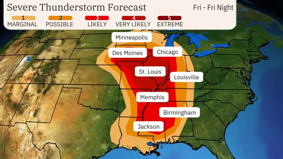
A volatile storm system continues to intensify and will remain a significant threat through the overnight hours. Today’s Level 4 severe weather risk is expected to escalate to a Level 5 “high risk” by tomorrow, signaling the potential for widespread and dangerous impacts.
The threat zone spans from the Midwest through the Mississippi Valley, with areas including St. Louis and Memphis at heightened risk late tonight into early morning.Forecasters warn that these storms could rapidly strengthen after sunset.
Nighttime tornadoes are statistically twice as deadly, making overnight weather alerts essential. Residents are urged to remain alert, have emergency plans in place, and be prepared to seek shelter immediately—even in the middle of the night—as the most severe conditions may strike while many are asleep.
Radar Update
From Jonathan Belles, Digital Meteorologist at Weather.com:
A quasi-linear convective system (QLCS)—a fast-moving squall line—continues its sweep through the Midwestern states, including Nebraska, Iowa, and Missouri.
The first tornado of the evening has been confirmed, coinciding with an increase in atmospheric moisture, which is now more supportive of robust thunderstorm development.As Gulf moisture surges northward into the Mississippi Valley, conditions are expected to further destabilize.
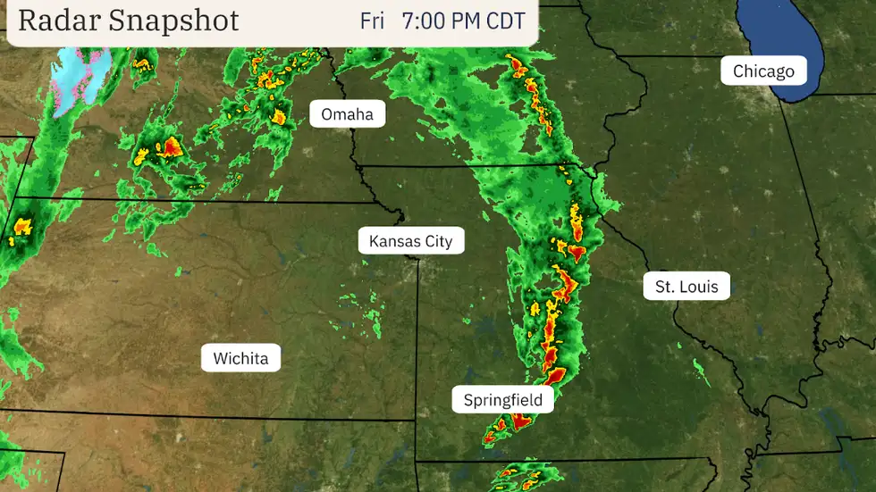
Heightening the tornado threat across Missouri, Illinois, and surrounding areas in the coming hours. In addition, strong, damaging winds persist across the Plains and are now beginning to impact parts of the Midwest, intensifying the overall severe weather risk.
What You Need to Know About Supercells
A tornado-warned supercell has been detected near Seymour, Missouri, where atmospheric conditions are rapidly deteriorating.Supercells are the most dangerous and long-lived type of thunderstorm.
Known for their distinctive “mothership” appearance and hook echo signature on radar, these storms are capable of producing large hail, destructive straight-line winds, and violent tornadoes.
Unlike typical thunderstorms, supercells can persist for hours, travel hundreds of miles, and evolve into high-impact severe weather events.
Their formation relies on intense atmospheric instability and strong wind shear, creating the perfect environment for rotating updrafts—a key ingredient in tornado development. Supercells are responsible for the majority of the world’s most powerful and deadly tornadoes.
Tornado Spotted Near Springfield, Missouri
A local meteorologist has successfully captured a photo of the tornado warned near Springfield, Missouri.As storms in Southern Missouri and northern Arkansas begin to dissipate, the region appears to be shifting toward a growing tornado threat, with conditions slowly becoming more conducive for tornado development.
Growing Fire Weather Threats Across Texas and the Plains
Texas and portions of the Plains are facing an escalating wildfire risk as fire seasons stretch longer and intensify. Shifting weather patterns and increasingly volatile conditions—such as today’s wind and dust storm event—are contributing to a significant rise in fire-prone days.
In west Texas, some areas are experiencing nearly two extra months of ideal wildfire conditions compared to half a century ago.The combination of hot, dry, and windy conditions creates a volatile environment, allowing fires to ignite quickly and spread at alarming rates.
This puts homes, power infrastructure, and entire communities in peril. With wildfires already raging across the state, experts predict these extreme fire conditions will only grow more frequent and devastating in the years ahead.
Tornado Warning Issued Near Springfield, Missouri
A tornado warning has been issued for areas near Springfield, Missouri, after radar detected an imminent tornado threat. Residents are urged to seek shelter immediately.Even if the tornado does not touch down, the region remains at significant risk due to the presence of strong, damaging winds that could threaten both life and property.
Powerful Wind and Dust Storm Sweeps Across Texas and Oklahoma
The National Weather Service has released a striking satellite animation capturing a massive dust storm engulfing parts of Texas and Oklahoma. The imagery vividly illustrates the storm’s wide reach and intensity, underscoring the scale of its disruptive force across the region.
Shifting Winds Pose Major Challenge for Fire Crews
From Jonathan Belles, Digital Meteorologist at Weather.com:
Firefighters on the ground are facing a new obstacle this evening—rapidly shifting winds. As a low-pressure system tracks northeast, wind direction across much of Oklahoma is expected to swing from the southwest to the northwest or west-northwest.
This abrupt change could compromise existing firelines, potentially redirecting flames and putting additional structures at risk.
Why Spring Brings Powerful Wind Events
Spring is notorious for strong and turbulent winds, particularly across the West, Plains, and Southeast—as dramatically demonstrated today. The culprit? A seasonal clash of air masses.
Cold air from Canada collides with warm, moist air from the tropics, and when high and low pressure systems converge too closely, the pressure contrast causes air to surge between them.
The greater this pressure difference, the stronger the resulting winds, turning spring into a season known for intense and sometimes hazardous gusts.
Evening Weather Outlook: Dual Threat Emerging
From Jonathan Belles, Digital Meteorologist at Weather.com:
As daylight fades, a dual severe weather threat is unfolding. In the Midwest, a developing squall line is producing strong winds and is expected to intensify as evening sets in, potentially escalating into a tornado threat.
Meanwhile, in the South, states including Arkansas, Louisiana, Mississippi, and Tennessee may see a brief but intense window of tornado and damaging wind potential before and after nightfall.Conditions are becoming increasingly volatile, and both regions face an elevated risk in the coming hours.
Understanding What ‘Severe Weather’ Really Means
When meteorologists talk about severe weather, they’re referring to much more than just heavy rain or thunder. It includes any atmospheric event that poses a threat to life or property—from tornadoes and hurricanes to flash floods, lightning, intense winds, and damaging hail.
Officially, a storm is classified as severe if it produces hail the size of quarters, wind gusts of 58 mph or more, or has a tornado risk—all of which are present or expected in today’s volatile system.
What You Should Know About Squall Lines
A squall line is beginning to develop over western Missouri—making now the perfect moment to understand why these storm systems are so dangerous.
These are narrow but long bands of powerful thunderstorms that surge forward rapidly, often producing damaging straight-line winds, blinding rainfall, frequent lightning, and sometimes even tornadoes. On radar, they often show up as dramatic, bow-shaped clusters.
When they sustain their strength and speed over a long path, they may evolve into a derecho—a violent storm system with hurricane-like force. If one is headed your way, prepare for sudden, intense conditions and stay alert.
Severe Weather Threat Expands Southward
According to the latest guidance from NOAA’s Storm Prediction Center, the risk of severe weather has intensified in southern regions of the alert zone.
The Level 4 (out of 5) risk area now stretches farther south into central Mississippi and northern Louisiana, with lower-level risks extended westward into parts of Louisiana and Texas.
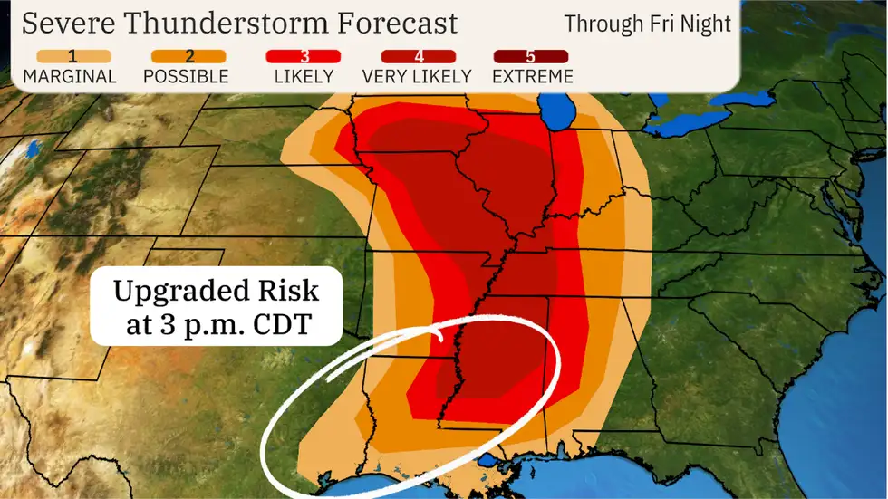
This update comes as confidence grows that supercell thunderstorms—capable of producing long-track, potentially violent tornadoes—will form this evening. Residents in these areas should be on high alert, as conditions are increasingly favorable for dangerous and fast-developing storms.
Satellite Imagery Reveals Intense Fire Weather Conditions
From Jonathan Erdman, Senior Meteorologist at weather.com:
A recent visible satellite image captures the severity of today’s fire weather outbreak across the southern Plains. Thick plumes of airborne dust are seen stretching from eastern New Mexico through western and northern Texas, into Oklahoma and eastern Kansas—some extending over 800 miles in length.
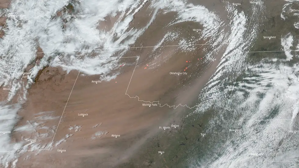
Highlighted by orange thermal signatures, the image also pinpoints active hot spots, indicating either new ignitions or ongoing wildfires. Satellite technology remains an essential tool in wildfire detection, allowing meteorologists to provide critical early warnings to local fire crews battling these rapidly evolving conditions.
Latest Wind Damage Reports
Recent severe weather events have caused widespread wind damage across several regions in the United States. From Missouri to Pennsylvania, high winds have uprooted trees, downed power lines, and caused significant structural damage.
On April 29, southwest Missouri saw gusts reaching up to 90 mph, resulting in over 50,000 power outages in Springfield alone. Similarly, strong winds in Pennsylvania downed trees and power lines, leaving many areas without power.
Nebraska and Iowa were also hit hard earlier in April, where a violent hailstorm produced 80 mph winds, causing extensive damage in just minutes. These incidents highlight the growing frequency and intensity of wind-related weather events, underscoring the importance of being prepared for unpredictable severe weather patterns.
Wind Shuts Down Amarillo Interstate
Severe winds, with gusts reaching up to 85 mph, have caused significant disruptions across New Mexico, Texas, and Oklahoma. The powerful winds, combined with blinding dust, are creating hazardous driving conditions, particularly on highways.
In Amarillo, Texas, parts of the interstate were closed due to the heightened risk of accidents and pileups. The dangerous combination of high winds and reduced visibility is making travel extremely risky, prompting authorities to take action to ensure public safety.
Saturday’s Forecast Upgraded to Rare ‘High Risk’ in the South
The National Oceanic and Atmospheric Administration’s (NOAA) Storm Prediction Center has issued a rare “high risk” severe weather warning for Saturday, extending from central Mississippi to central Alabama.
This update signals an elevated threat of long-track and potentially violent tornadoes, particularly in the afternoon and evening hours.According to the SPC.
“A tornado outbreak is likely on Saturday across the central Gulf Coast states, the Deep South, and into the Tennessee Valley,” with numerous significant tornadoes expected, some potentially long-track and violent in nature.
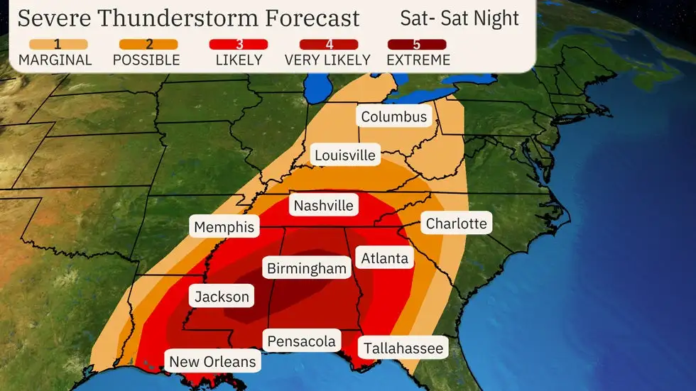
The “high risk” designation is only issued two to three times a year, highlighting the severity of this storm system. While the darkest red zone represents the highest threat, a much larger area, including parts of eastern Louisiana, western Georgia, and northward to Tennessee, also faces significant risks from tornadoes and widespread wind damage.
Updated Severe Storm Forecast
The Storm Prediction Center has issued an updated forecast for this afternoon, with slight adjustments to the timing and outlook. Meteorologists now expect storms to begin earlier than previously anticipated, likely around 3-4 p.m. CDT, or possibly even a bit sooner.
As a result, the level 2-4 risk areas in Missouri have been shifted slightly to the west to reflect the new timing.
Severe Winds Impact Texas Panhandle
The Texas Panhandle is grappling with extreme winds, as gusts reached up to 70 mph in Vega, located west of Amarillo. The intense winds, coupled with dust storms, have created dangerously low visibility, making travel perilous.
One driver shared a harrowing video of his experience navigating the area, recounting over 150 miles of near-zero visibility during his journey from New Mexico.
Frequently Asked Questions (FAQS)
What is a “high risk” severe weather alert?
A “high risk” severe weather alert is the highest level of warning issued by the Storm Prediction Center (SPC). It indicates a significant likelihood of severe weather events, such as long-track, violent tornadoes, large hail, or damaging winds. This level of threat is issued only a few times each year.
What does “severe weather” include?
Severe weather includes conditions that threaten life and property, such as tornadoes, hurricanes, thunderstorms, hailstorms, blizzards, ice storms, floods, and extreme heat. Severe weather is often accompanied by high winds, lightning, and heavy rain.
What is a squall line, and why is it dangerous?
A squall line is a long, narrow line of thunderstorms that can produce heavy rain, damaging winds, hail, and even tornadoes. These storms move quickly and can last for hours, making them particularly dangerous for areas in their path.
Why do winds become stronger in the spring?
Spring is a season of temperature contrasts. Cold, dense air from the north collides with warm, moist air from the south, creating pressure differences that result in strong winds. These winds can be particularly hazardous in the Plains, West, and Southeast regions of the United States.
How do meteorologists predict severe weather?
Meteorologists use a combination of weather data, including satellite imagery, radar readings, and computer models, to forecast severe weather. They analyze factors like atmospheric pressure, wind patterns, temperature, and moisture levels to predict storms, tornadoes, and other hazardous weather.
How do fire weather warnings work?
Fire weather warnings are issued when conditions are ideal for the rapid spread of wildfires. Factors such as high winds, dry conditions, and high temperatures contribute to the fire danger. These warnings help alert the public and firefighters to the risks of fire outbreaks.
Conclusion
The recent combination of tornadoes, wildfires, and dust storms across Missouri, Mississippi, and the Plains highlights the increasing severity of extreme weather events. These destructive forces have left communities in chaos, with emergency crews working tirelessly to assist affected residents.